Infos :
Pictures :
Site Links :
Help of travel :
|
|
South Africa : Climate & geography
Prepare your travel to South Africa
I. Geographical situation of South Africa
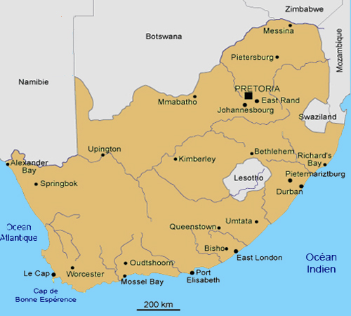
South African Map
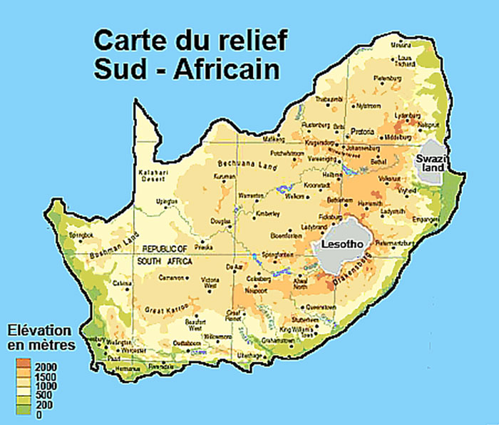
Relief Map of South Africa
|
South Africa covers 1,219,090 square kilometers, twice and half of France.
West to east, it shares a border with Namibia (855 km), Botswana (1840 km), Zimbabwe (225 km), Mozambique (491 km) and Swaziland (430 km).
The country is bordered on approximately 3 000 km by two oceans: the? The Atlantic And west The Indian Ocean Is.
In the southeast quarter of the territory is the landlocked kingdom of Lesotho.
The relief of South Africa is simple. It is divided into three zones:
- A vast interior plateau of semi-circular with an altitude ranging between 1 200 and 1 800 meters.
- A narrow coastal plain.
- A region Successive escarpments separating the plains and the plateau.
The Drakensberg mountain range can reach heights of 3000 meters, but its peak (3482 m) is located in Lesotho.
Savannah poor (bushveld) dominates vegetation that can be temperate or tropical depending on latitude.
Extremely rich floral heritage, with over 1300 species per 10,000 sq km, is greater than that of Amazon.
We meet, however, little lakes and forests.
The Northern Cape is the largest (363,390 square kilometers) with Kimberley capital.
Johannesburg and Pretoria, however, are located in the smallest province Gauteng (18 760 km ²).
|
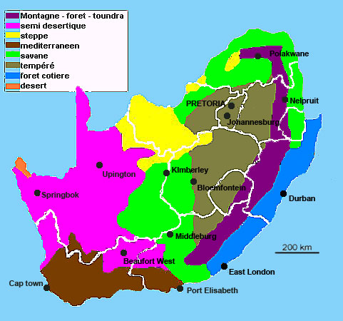
II. Climatic situation in South Africa
Climate map of South Africa
|
The South African summer begins in October and ends in March.
Temperatures during this period are between 15 degrees at night and 35 degrees at noon.
Winter, which runs from April to September, with temperatures ranging from 0 degrees or less at night to 20 degrees at midday.
Despite some differences in temperature in different regions, the South African climate is generally mild throughout the year.
Although there is some snow on the highest peaks, South Africa is an arid country and has many warm sunny days.
Annual rainfall of about 502mm.
KwaZulu-Natal experiencing a subtropical climate with a humidity level was important.
The southern part of Mpumalanga knows it, very hot summers with occasional torrential storms.
|
Mainland Cape and Free State have a climate similar to that of Mpumalanga.
Finally, the Western Cape enjoys a Mediterranean climate characterized by hot dry summers and cold winters and humid.
Definition :
Tundra: Type ecosystem dominated by lichens, mosses, grasses and woody plants. The tundra is present at high latitudes (arctic tundra) and high altitudes (alpine tundra).
semi-desert subdesert Zone, characterized by a dry season extending over much of the year and a season "wet", with low precipitation (rainfall between 100 and 400 mm / year).
Steppe: Great Plain with low vegetation.
Mediterranean: The Mediterranean climate is considered mild, but according to geographic conditions (presence of the Mediterranean Sea for example), it is subject to special climate and weather events: storms (eg storm Cevennes) , summer drought.
Savannah: Landscape of tallgrass prairie, dotted with trees in the tropics.
Temperate: cold season (winter) and a hot season (summer). It is divided into two major subgroups: the oceanic climate with cool summers and mild, wet winters influenced by the proximity of the oceans where there are warm currents (west side of continents) and the continental climate with summers Hot and stormy and cold winters and relatively dry (facade continents).
Coastal Forest: type evergreen temperate forest. Coniferous or deciduous, it is found in temperate latitudes, in areas where precipitation is abundant.
Desert area sterile, or hostile to life, due to unsuitable soil or low rainfall (less than 200 mm per year). A desert landscape is distinguished by its naked appearance. A desert is outside ecumene.
|
III. Temperatures and rainfall in major cities in South Africa
Durban |
January |
February |
March |
April |
may |
June |
July |
August |
September |
October |
Nevember |
December |
Temperature max |
27 |
27 |
27 |
26 |
24 |
23 |
22 |
22 |
23 |
24 |
25 |
23 |
Temperature min |
21 |
21 |
20 |
18 |
14 |
12 |
11 |
13 |
15 |
17 |
18 |
19 |
Rainfall (mm) |
109 |
122 |
130 |
76 |
51 |
33 |
28 |
38 |
71 |
109 |
122 |
119 |
Johannesburg |
January |
February |
March |
April |
may |
June |
July |
August |
September |
October |
Nevember |
December |
Temperature max |
26 |
25 |
24 |
22 |
19 |
17 |
17 |
20 |
23 |
25 |
25 |
26 |
Temperature min |
14 |
14 |
13 |
10 |
6 |
4 |
4 |
6 |
9 |
12 |
13 |
14 |
Rainfall (mm) |
114 |
109 |
89 |
38 |
25 |
8 |
8 |
8 |
23 |
56 |
107 |
124 |
Cape Town |
January |
February |
March |
April |
may |
June |
July |
August |
September |
October |
Nevember |
December |
Temperature max |
26 |
26 |
25 |
22 |
19 |
18 |
17 |
18 |
18 |
21 |
23 |
24 |
Temperature min |
16 |
16 |
14 |
12 |
9 |
8 |
7 |
8 |
9 |
11 |
13 |
14 |
Rainfall (mm) |
15 |
8 |
18 |
48 |
79 |
84 |
89 |
66 |
43 |
30 |
18 |
10 |
Pretoria |
January |
February |
March |
April |
may |
June |
July |
August |
September |
October |
Nevember |
December |
Temperature max |
27 |
27 |
26 |
23 |
21 |
18 |
18 |
21 |
24 |
25 |
26 |
27 |
Temperature min |
19 |
18 |
17 |
14 |
10 |
6 |
6 |
9 |
13 |
15 |
16 |
18 |
Rainfall (mm) |
120 |
90 |
80 |
40 |
20 |
0 |
0 |
0 |
20 |
50 |
100 |
110 |
V. Weather forecast in South Africa
Weather Forecast Johannesburg, Cape Town, Durban, Pretoria ...
Source : 2008
|
|
|
|
|
|
|
|