Infos :
Namibia
South Africa
Botswana
Zimbabwe
Pictures :
Namibia
South Africa
Botswana
Victoria Falls
Site Links :
Travel Journal
Videos
Forum
GuestBook
Help of Travel :
Car Rentals
Plane Tickets
Your holidays
Hotels
Currency Converter
Facts
Maps
Money
Accommodation
Transportation
Formalities
Health-Safety
Climate & Geo
People
History
National Park
Fauna
Links
Move to Zimbabwe
Prepare your travel to Zimbabwe
I. Rent a car in Zimbabwe
II. General Information
III. Roads photos
IV. Top airports
V. Map and information for rail network
VI. Transit Map
I. Compare to rent your car in Zimbabwe
II. General Information of Zimbabwe
Railway: 3.077 km
Route: 18 338Km whose 9664 track
Airport: 204 including 17 paved
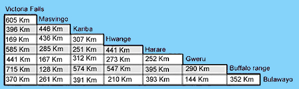
Distance Table:
Distance between the cities of Zimbabwe
III. The roads of Zimbabwe in pictures
Stage:
Kasane - Victoria Falls
Quality:
tar
Average speed (standard drive):
100Km
Road between Kazungula and Victoria Falls
IV. Zimbabwe's main airports
Civil Airports and Airfields-Bulawayo
Harare International Airport
Kariba
Victoria Falls
V. Map and information of the railway network in Zimbabwe
Railway lines in Zimbabwe
Link:
National Railways of Zimbabwe
.
VI. Transit in Zimbabwe
Buses are a good means of transportation to get around the country.
There are several bus company as
Blue Arrow
and
Intercape Mainliner
.
There are also different as the express bus company, Trans-read or Jacaranda Luxury Coach.
Source : 2008
Partners
Sitemap