Infos :
Pictures :
Site Links :
Help of Travel :
|
|
|
Namibia: Caprivi Strip
Prepare your travel to Namibia
|
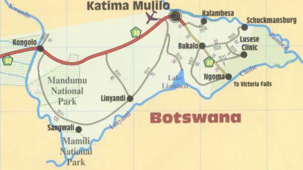
Caprivi map
» Location
The Caprivi Region is located at the north-eastern Namibia.
It consists of the eastern Caprivi Strip and the former East Caprivi Bantustan (or Lozi).
480 km long, the Caprivi region is bordered by Botswana to the south, Angola and Zambia to the north and Zimbabwe to the east.
The region is divided into six districts: Kongola, Linyanti, Sibinda, Katima Mulilo Urban Katima Mulilo Rural and Kabe.
The county seat and largest city is Katima Mulilo .
» Climate Location
The Caprivi region has a typical tropical climate with high temperatures and heavy rainfall during the rainy season extends from December to March.
Making it the wettest region of Namibia.
The territory consists mainly of wetlands, floodplains, wetlands and woodlands.
The Caprivi region is irrigated by several permanent streams:
the Zambezi forms the border with Zambia, and streams: the Cuando and the Chobe River forms the border with
Botswana and Linyanti. The easternmost point of the region (and Namibia) is the confluence of the Cuando and
Zambezi.
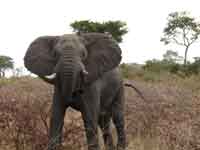
There are 450 species of animals, including Elephants , making the region a popular destination for hunting big game.
The Caprivi region is also an exceptional area for bird-watching, with nearly 70% of bird species recorded in Namibia.
» History
Caprivi was named after the band of the same name and is the German Chancellor Leo von Caprivi.
It negotiated in 1890 a land swap with the United Kingdom to ensure that this strip of land be
attached to the South-West Africa, in order to give the German colony access to the Zambezi in the Treaty of
Heligoland-Zanzibar.
In 1964, the report of the Odendaal Commission recommends the creation of homelands in Namibia as part of the policy
conducted by the apartheid government of South Africa.
What is now the Caprivi region is then divided between the Bantustans and Kavangoland Caprivi Oriental
in 1972 and the Eastern Caprivi wins independence in 1976. The Bantustan is then used in the context of SWAPO incursions
coming from neighboring Angola. In May 1989, the homelands were reintegrated into Namibia and current regions are created
time of independence in March 1990.
Ethnic tensions between the Lozi and the Ovambo, the largest ethnic group in northern Namibia,
then lead to conflicts and the formation in 1994 of the Caprivi Liberation Front which is fighting for autonomy
Lozi of Caprivi.
» People and Towns
Katima Mulilo is the county seat and largest town in the Caprivi region.
Other important cities are Choi Chinchimane, Bukalo, and Sibinda Impaliola.
At the 2006 census, 79,826 people live in the Caprivi region, representing 4.3% of the total population
Namibia.
In 1991 the population was 90,422 people. About 17,000 belong to the ethnic Lozi, group
Ethnic present also in western Zambia (556 000), in the northwestern Zimbabwe (70 000 persons)
in northern Botswana (14 000 persons).
» Parks and nature reserves
Wildlife is protected by several natural reserves
such as Bwabwata the Mudumu and Mamili National Park.
The animals move freely across borders (not marked on the ground) with the < font color=#3366FF> Botswana
in the Chobe National Park.
|
Bwabwata National Park
|
|
The whole western part of the Caprivi now has the status of animal reserve.
In 2002, the National Park Mahango (Mahango National Park) and the animal park in western Caprivi (Western Caprivi Game Park)
were combined to form the National Park Bwabwata (Bwabwata National Park) ...
|
|
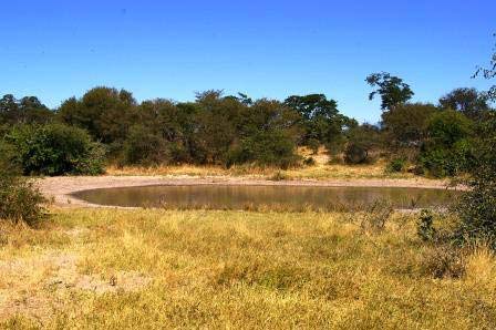
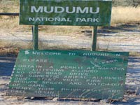
Mudumu National Park
|
|
Mudumu Nature Reserve is open to visitors although there is no infrastructure provided for tourists (except Lianshulu lodge, located on a concession in the heart of the park).
its 75 000 hectares of land, protected since 1990, are mainly covered with mopane * * Terminalia, Acacia, * Teks of Rhodesia and fens.
Exeptionnelle wildlife that inhabits the river Kwando (which becomes the Linyanti river where branches off North-east, the south end of the Caprivi Strip, Chobe then becomes the east of Lake Liambezi) ...
|
|
Mamili National Park
|
|
No humans in this swampy, inhospitable savannah of 350 km2, impenetrable to the rainy season and dry the rest of the year.
Elephants
hippos
buffalo
antelope and many others, share the dense vegetation and tall grass.
The many trunks that seem to float on the arms of the Linyanti River are crocodiles ...
|
» Photos
- Pics of
Caprivi Strip .
» Accommodation
- Namushasha Country Lodge - Salambala Campsite ...
Source : 2008
|
|
|
|
|
|
|
|
|