Infos :
Pictures :
Site Links :
Help of Travel :
|
|
Sossusvlei & Namib desert
Prepare your Travel to Namibia
|
|
|
|
Sossusvlei and Namib Desert
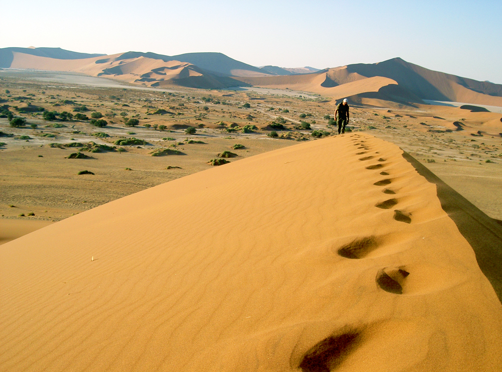
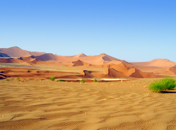
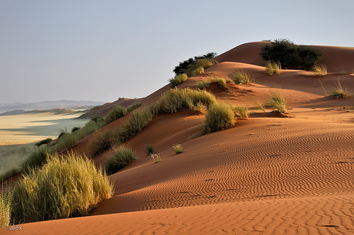
 Namib dunes
|
|
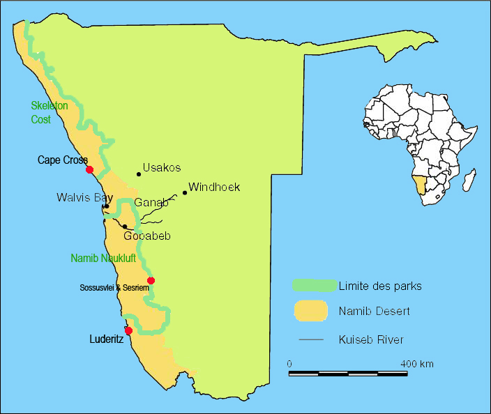
I. Namib desert
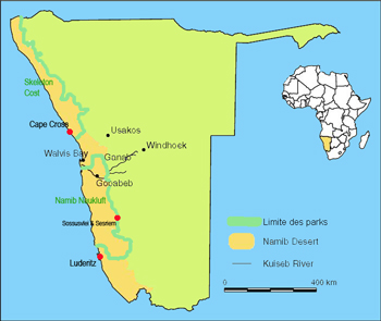
Namib Desert Map
|
The Namib desert is a hot coastal desert, located in south-western Namibia.
It is considered the oldest desert in the world, subject to conditions as arid or semi-arid regions since at least 55 million years.
Desert conditions prevailing there are consequences of the cold Benguela sea current of Antarctic origin, which cools the oceanic air masses off the coast of Namibia.
When these air masses arrive over the mainland warmer, they heat up and expand, which prevents them from releasing the moisture they contain as rain.
Morning mists are still frequent, and bring a little moisture in the desert up to 50 km offshore.
The desert occupies an area About 80 900 km2.
It Extends over 1500 km along A coastal strip north-south off of 80 160 km along the Atlantic Ocean.
|
It is a transition zone semi-arid region is bordered by a mountain plateau.
To the south, the Namib Desert merges gradually with the Kalahari Desert.
The desert is virtually uninhabited, except for some isolated coastal communities and cities such as Swakopmund, Walvis Bay and Luderitz.
Places to see are inescapable:
The Skeleton Cost:
Coast Kaokoland and by extension the entire coast of Namibia is named Skeleton Coast, evoking the plight of hapless castaways, following the combination a strong ocean current, and frequent fogs an inhospitable desert coast.
The coast is dotted with whale bones and shipwrecks stranded and partially covered by sand.
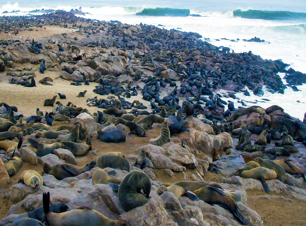
Cape Cross :
The Portuguese navigator Diogo Cão erected at that place a stone cross (Padrão) in 1486 to mark the furthest point south ever achieved by Europeans in Africa at that time.
Today, Cape Cross has a very large colony Fur seals.
 The Cape Cross in Namibia
Sossusvlei as well And we'll talk in detail about this page ...
II. Sossusvlei
Sossusvlei is the most accessible part of the sea of ??sand.
A road of 65 km National Park Namib-Naukluft allows? Access from Sesriem to Sossusvlei beautiful orange dunes.
At the foot of the dunes are the vlei, rarely flat expanses filled? Water.
The most famous is Dead Vlei with its dead tree below the huge dune Big Daddy.
At Sesriem, a deep canyon of 40 m and a length of 3 km has been carved by the river once Tsauchab.
Tsauchab River, born in the mountains of naukuft, created his bed through the sands of the Namib Desert.
In the mid-nineteenth century, yet it joined the Atlantic Ocean.
But it has dried, and the dunes of Sossusvlei have made it an insurmountable barrier.
From the park entrance, this wide valley sinking into the desert and finds its way into a tangle of red sand dunes, pink or tan depending on time of day, at the foot of which ACASIA erioloba centenarians stand proudly.
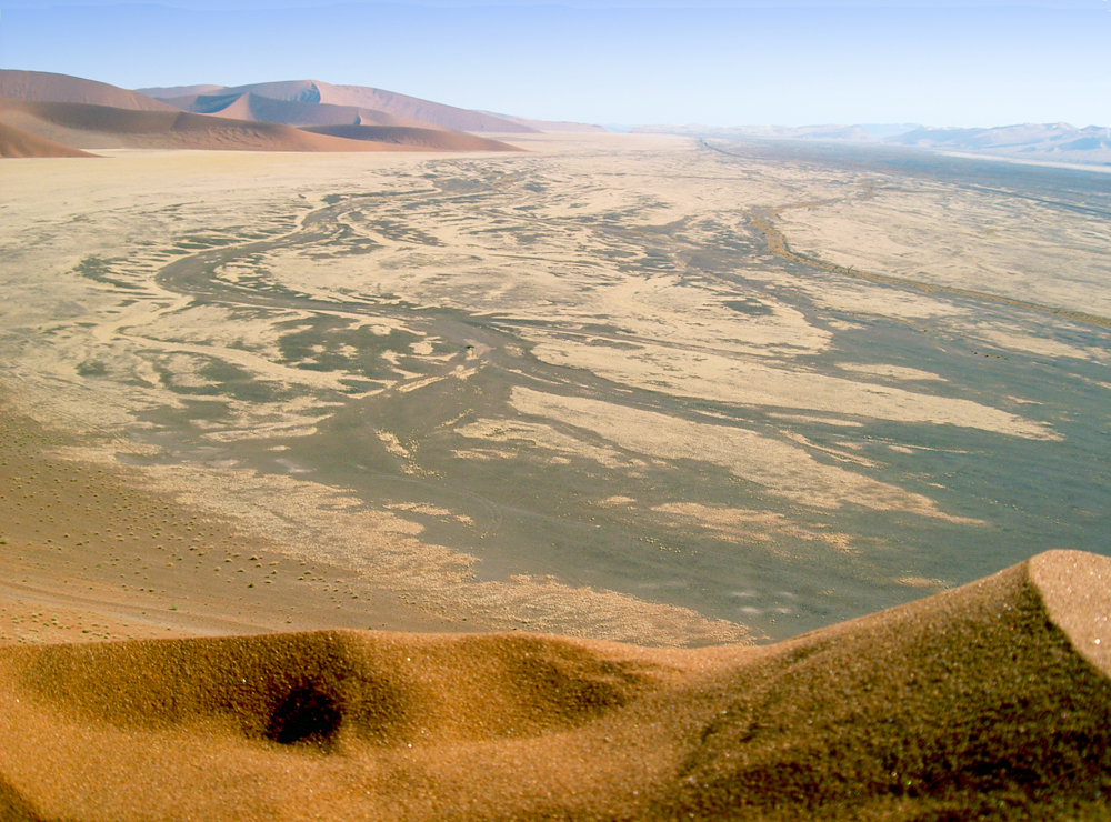
 Pan Sossusvlei in the Namib Desert's door
Less known than Sossusvlei, this part of the park possesses a different charm and, some more subtle than the sea of dunes, the sand because it constantly mixing granite hills in shades of brown.
On the vast plains grazing Oryx, Springboks and Ostrich .
The more we advance towards the west, the sand becomes more profound, the dunes are tightening.
4km from the site of Sossusvlei 4x4 can only continue on the track (a shuttle is provided for those who do not).
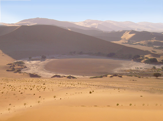
The site itself is a cup blanched ground, a dry lake in the middle of a circus dunes.
Years of heavy rains (quite rare in this region) are the Sossusvlei filled with water, forming a lake visited by many birds amidst a sea of sand!.
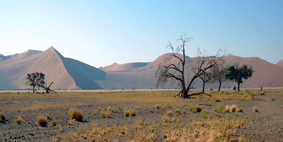
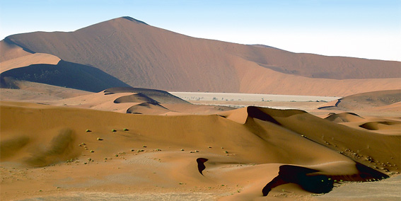
 Dunes of the Namib Desert
The Dead Vlei, a bowl to the hard ground with a whitish crust of Sossusvlei Alée stands by its isolation from the riverbed.
As its name suggests, ever more the Dead Vlei does not receive water from the river.
Skeletons of trees dansd cup frozen white convey an impression of desolation absolutely magnificent.
Sesriem Valley is best visited early in the morning for a sunrise in the dunes or a few hours before sunset because the rest of the day, the sun can be very hot.
III. Procedures and points of interest Sossusvlei
Formalities
Price of entry permit (at the Sesriem campsite): 80 N $ per person.
The cost of the shuttle from the parking to Sossusvlei dunes: 100 N $ per person (round trip).
Points of interest:
Section Sesriem organized along the valley of the river which ends Tsauchab pans of Sossusvlei and Dead Vlei, giving way further west into the sea of unbroken dunes to the Atlantic Ocean.
Sites of Interest sonr described from west to east, ie the site of Sossusvlei to the entrance of Sesriem.
Sossusvlei
Sossusvlei
|
350m red sand dunes of the world's highest border Sossusvlei, laura and thousands of little sisters formed a sea of sand over 100 miles away.
"Big Mama" north and "Big Daddy" to the south are the names given to small dunes overlooking the landscape of Sossusvlei or is pure red and orange dunes, blue skies and white salt crust spotted here
and by the green dots the desert shrubs.
The red color is due to xydation sand, probably originated in the Kalahari
and transported to the Atlantic Ocean by the Orange River in southern Namibia,
then reassembled by the Benguela current on the Namibian coast.
The strong winds from the west, would, from the coast, drove the sand inland, forming a dune belt nearly 100 km offshore.
|
|
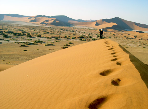
It is possible to climb the Namib dunes walk (allow at least 1 hour for the highest), preferably in the morning at sunrise, for photographic images in a fresh light and to avoid écrassante heat of the day.
|
Dead Vlei
Dead Vlei in Namib Naukluft
|
South of Sossusvlei, a footpath leads to the Dead vlei along bushes "nara" (surprisingly green thorn bush that produces fruit ressenblant in cucumber and melon, and whose seeds are eaten by Nama ).
An almost mystical landscape composed of dead trees stuck in a white bowl in the dunes have red
Orange offered then the contemplative.
We appreciate even more the place he is still little visited.
The rise of the dune overlooking the Dead Vlei is likely more intimate than the single file occupies sometimes other dunes.
|
|
Once on top, it's nice to come down directly on Dead Vlei, the acoustic sound produced by each step enhances the pleasure of the descent.
|
Dune 45
Dune 45 in Namib desert door
|
At about 50km from Sesriem (park entrance) to the south indicated the famous dune 45, presumably the dune park's most climbed!
Given its relative proximity to the entrance, there are many who will attend the sunrise or the sun Couhe on this dune.
The dune 45 also marks the narrowing of the valley.
The riverbed Tsauchab very distinct with its tree line starts to get closer to the road (or vice versa) to meet her at Sossusvlei.
To the east of the dune landscape combines the dunes and mountains
with a spectacular view, especially at sunset.
|
Elim Dune
Elim Dune
|
Located just 1.5 km from the camp (turn right after a few hundred meters towards Sossusvlei), it is an ideal stage upon arrival in late afternoon to Sesriem (valid especially if you spend the night at camping).
From the top of the dune, the panoramic view is stunning: a belt of red dunes to the west and a vast plain pastel colors crossed by an impressive mountain range to the east.
Sesriem since you can get there on foot to stretch your legs and forget about hours drive
Geckos singing accompany you, look in the ground, you will see small burrows where they took refuge in the approach of visitors.
|
Sesriem Canyon
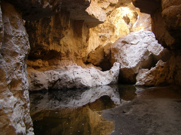
Sesriem Canyon
|
Created by Tsauchab, the canyon offers a geological structure of the more interesting: the clusters showing a rock formation dating back over 15 milion year s.
Sersriem means "six belts" zn Afrikaans, with reference to the efforts of the Boers who named the place, once forced six straps to attach the other one to the handle of a bucket to be able to fonddu Water Canyon .
The visit deserves to be a walk (approx 2 hours), along the fault, inhabited by a large colony of pigeons rocks.
Descending into the gorge, more than 30 meters deep to grow gigantic ACASIA, you can continue your trek through the bed of the Sesriem Tsauchab
before returning to the plain, where you will see Oryx
and Springboks
(the snakes are frequently out late in the day).
|
Surval dunes by plane or balloon:
Two absolutely wonderful experience but very different plane overflying proposed by many company gives
the opportunity to browse the sea of dunes to the coast where sand dunes flowing into the sea, occupied here and there by
a Seal colony
and scarred by the wrecks of sunken ships or the remnants of the construction camps of the railway line
Walvis Bay -
Luderitz
never finished.
The Balloon flight in the morning silence, is offered by the now famous company
Namib Sky Adventure Safari.
IV. Access to the park
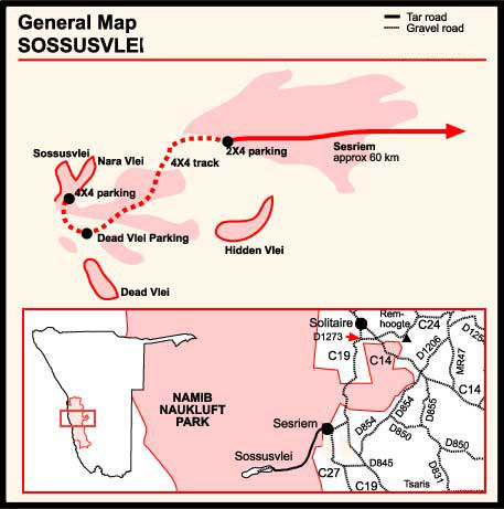
Map of sossusvlei
|
From the south, C27 leads to Sesriem including through the reserve giving access to little Kulala Wilderness Safaris camps bordering the park.
From the north or the south west, C19 meets the D826 leading to Sesriem, the entrance to the section in question.
Open all year from sunrise to sunset, the park, managed network of talking National Wildlife resorts requires a registered license.
Sesriem this section for some years a paved road up to 4 km from Sossusvlei to the bottom of the valley.
From the car park in 4x4 is required to join the site, shuttles are provided for those who do not.
From personal experience, less 4km remaining are possible on foot.
|
V. Climate Sossusvlei
The dunes are a certain amount of moisture from the ocean nearby and allows the existence of a fauna adapted to the harsh climate.
Desert of Namib |
January |
February |
March |
April |
May |
June |
July |
August |
September |
October |
November |
December |
Temperature max |
30 |
29 |
27 |
26 |
23 |
20 |
21 |
23 |
37 |
29 |
30 |
31 |
Temperature min |
17 |
17 |
15 |
13 |
9 |
7 |
6 |
9 |
12 |
15 |
16 |
17 |
Rainfall (mm) |
8 |
9 |
8 |
4 |
1 |
0 |
0 |
0 |
0 |
2 |
4 |
5 |
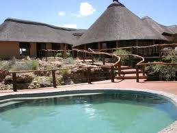
VI. Accommodation in Sossusvlei
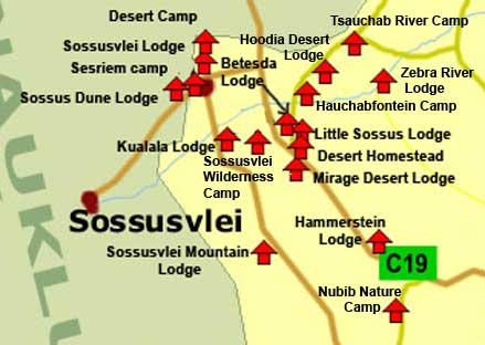 Map of Accommodation in Sossusvlei region
|
» Inside the park:
- Sesriem Camping
Price: N$ 150 par personne + N$ 300 per site.
Namibia Wildlife Resorts, PO Bag 13267, Windhoek
Tel: +264 (061) 236 975
reservations@nwr.com.na
|
- Sossusvlei Lodge
Rate between N$ 1575 and N$ 1915
P.O. Box 6900
Ausspannplatz, WINDHOEK, Namibia
Tel: +264 63 693-223
adventure@sossusvleilodge.com
|
» Outside the park :
All hotels / lodges and campsite in the area of Sossusvlei & Sesriem:
» Hotels & Lodges in Sesriem / Sossusvlei
» Sossusvlei & Sesriem Campsite
VII. Sossusvlei Photos
- Pictures of Namib desert & Sossusvlei
VIII. Book on the Namib desert
- Places in the Sand
- Namib
- Travel journal to Sossusvlei
Source: 2011
|
|
|
|
|
|
|
|