Namibia Arroukatchee Southern Africa

Infos :

Namibia
South Africa
Botswana
Zimbabwe

Pictures :

Namibia
South Africa
Botswana
Victoria Falls

Site Links :

Travel Journal
Videos
Forum
GuestBook

Help of Travel :

Car Rentals
Plane Tickets
Your holidays
Hotels
Currency Converter


kamanjab


Facts
Maps
Money
Accommodation
Transportation
Formalities
Health-Safety
Climate-Geo
People-Towns
History
National Park
Fauna
Links

Kamanjab

Travel guide of Kamanjab in Namibia


Town of
Kamanjab
Map Tourist Attraction Car Rental Flight
Plane tickets
Campsite
Rest Camp
Hotel
Lodge
Weather
Climate


I. Kamanjab travel guide


kamanjab location
Location of the town of Kamanjab
kamanjab

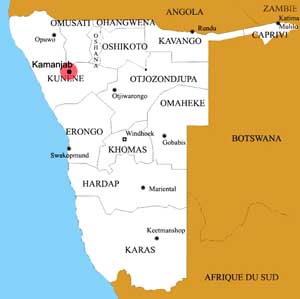
Kamanjab is located in the Kunene region, 108 km north of Khorixas, the city has about 6000 inhabitants.
Kamanjab is at the junction between the C35 route from north to south and C40 towards Outjo.

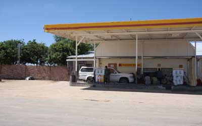
Kamanjab City has the infrastructure necessary to spend the night or resupply.
There is a gas station 24 / 24, a bakery, supermarket, post office and even a police station.
Kamanjab is the last town before you step back in Damaraland and Kaokoland, otherwise you will reach Opuwo and Ruacana.


II.Information on other towns in Namibia

Arandis
Aranos
Aus
Bagani
Gobabis
Grootfontein
Henties Bay
Kamanjab
Karasburg
Karibib
Katima Mulilo
Keetmanshoop
Khorixas
Khowarib
Kongola
Luderitz
Maltahohe
Mariental
Okahandja
Omaruru
Ondangwa
Opuwo
Oshakati
Oshikango
Otavi
Otjiwarongo
Outapi
Outjo
Purros
Rehoboth
Ruacana
Rundu
Swakopmund
Tsumeb
Uis
Usakos
Walvis Bay
Windhoek


Source : 2011


Partners
Sitemap